Caltopo – Why you need to check this mapping software out
Caltopo – Why you need to check this mapping software out Wil Rickards Does this sound familiar? You have pored over a particular map in silent wonder, and it has fueled your imagination. Navigation is one of the cornerstones of safe adventures. And, while it is not a typical topic of conversation at a…
Does this sound familiar? You have pored over a particular map in silent wonder, and it has fueled your imagination. Navigation is one of the cornerstones of safe adventures. And, while it is not a typical topic of conversation at a cocktail party, I find it fascinating. If you feel the same, you will want to read this. If you take part in adventures and you don’t, then you need to. I remember first coming across Caltopo.com. I was excited, like Baggins, our dog, chasing a squirrel excited. But first a back story.
My father was a charted surveyor, and he filled the house with cases of Ordnance Survey 1;10,000 scale maps. The detail was incredible, and they were beautiful, I loved them. In the UK, there is a history of “conquer and map it.” I am sure there are more cartographers per capita than any other country. British maps are so detailed and accurate in a way you cannot appreciate until you have used them. It is a good thing because the weather sucks. I do not exaggerate when I tell you I have crawled clients off Scottish winter mountains. It is not uncommon to have 100 mph winds and whiteout conditions. We stayed attached to the climbing rope, so I did not lose them. Meanwhile, I followed a bearing, trying to estimate the distance as best I could. Crawling is different from pacing.
In Scotland, I always had two maps on me in case one blew away. I laminated them and drew lines and detailed bearings and distances in Sharpie. Every exit from all the routes and summits I was likely to work was marked. You don’t want to be trying to measure and work out that info when the weather is battering you.
An Ordnance Survey 1:25,000 map. Look at the detail. Walls, crags, land cover are all accurately marked.
I treated my students the same way I would assess candidates on a mountain leadership award. I expected them to navigate at night to simulate lousy weather. I would ask them to find points on the map, forks in streams, wall junctions, and contour features like a small knoll. I expected them to evolve to a state where they could walk with confidence and be within 50 meters of a point. They had to explain their process and reasoning. We spent a lot of time pacing and timing to refine this capability. Uphill, downhill, diagonally across contours, I wanted them to feel the map and know what was going on.
Then came the advent of GPS. I was reticent to adopt it. Not because it is technology and technology can and does fail. I disliked it because it took navigation to a place of reaction rather than proactivity. I liked my students to look at the map, describe what they were going to see as they walked a route, then put the map away. As they walked, they checked off the features they noted. They pulled out the map again when things did not happen the way they predicted, or they reached the end of their leg. GPS means you know where you are, but it doesn’t necessarily encourage you to know what’s around you. I felt like an old fart hanging on to old ways, but in my heart, I knew it was wise.
When I started teaching in Colorado, I would have the students draw UTM lines on their USGS 7.5’ topo maps. My colleagues were using stoichiometry, the science of conversion, to help navigation. It sucks worse than the British weather. The students looked baffled, so I introduced the benefits of the metric system. I would pace out 100 meters on the flat, and we would time how long it took to walk it. If it takes 1.5 minutes to walk 100 m, then 1000m or a kilometer or one of those UTM squares takes 15 minutes. The students enjoyed the simplicity of dividing by ten, and so they humored me. Before too long, they were learning to be proactive.
Caltopo was the first online mapping software I found where I could print UTM gridlines on the map. It saved drawing them in. I could also print off the maps having typed details and information on them. I could create them using my scale of choice. I was so happy to go back to 1:50,000 or 1:25,000 maps. Even better, I could print maps of only the area I wanted. Slope angle shading came not long after, and it was a game-changer. Printing a map that highlighted the steepness of slopes instigated a discussion. We predicted places that were likely to hold the potential for an avalanche. We could also see what slopes were doing above our intended route. Not only that, but the shading was also simple enough that my eight years old understood it. Now 15, he has used this facility to plan hut/ski trips for years. He is capable of reading a map to both navigate and figure out a likely safe passage. He is proud he navigated a group out of a hut trip while I nursed a broken leg at home. He was 11.
My son’s first 14er ski. By creating the map together he was able to have at least an idea of what he was getting into.
So now you know why I love it. Why should you use it?
Base Maps:
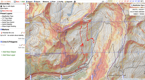
Navigation, to me, is about using a map to predict what you are going to see. Then you correlate that with what happens on the ground. When I first arrived in the States 20 years ago, I struggled with the USGS maps. They were often 40 years out of date. The contours were not always correct, and they lacked the information I liked. I use the 3 D’s to predict—Details, Distance, and Direction. I start by looking at Details, especially the contours, to gain a sense of the shape of the land. What am I going to feel as I pass along a route? Then I look at what features I will pass or see? With CalTopo, I can choose from many base maps. I can then superimpose satellite images and other layers onto the contours. No longer do I get confused when I pass through an area that burned a decade ago without being remapped. Everything is current. I often start with the Map Builder Hybrid. I can choose what contours to superimpose, 40’ is traditional, 5m (15’) is beautifully nuanced. I then add slope angle shading, which helps me to see likely avalanche danger. I also recognize how hard I am going to be working. I can also add sun exposure or wind forecasts so I can predict where I am going to find the best and safest snow. In spring, I can put on a satellite image that is less than a week old. How cool is that? I can find that elusive couloir that is still hanging on when everything else has melted out. As already mentioned, I add UTM grids so I can see a kilometer on the map. When I know the distance and the height gain and loss, I can work out the timing. On the ground, I measure distance by time, or if I need to be precise by pacing. This way, even if I cannot see what is around me, I can still have a good idea of where I am.
Up to date, UTM (1-kilometer grids), set your contours, scale, and slope angles. A handy tool.
Search Facility and essential tools:
Regardless of if you use Caltopo.com or the app, you can search for the place you want to navigate. No pulling out your catalog of maps. Unlike a paper map, you can then zoom in and out to see details or gain an overview. If you do print it up (I encourage having a printed sheet with you), then you can have the specific area you need and no more. I put two maps printed on letter paper back to back in a clear plastic sleeve and then use duck tape to seal it. It is smart to use the same scale for each of your maps, so they are consistent. As stated, I use either 1:25,000 or 1:50,000 as I am used to those scales, and the math is easy if I think in metric. On the app, you can also use GPS to pinpoint where you are and track your route.
iOS app – Yes you can use the GPS and add other people’s tracks before you start.
Collaboration:
Another neat thing about software is that you can collaborate. Create a map, share it via an URL. Create a profile of your route or the view from a particular point. Have friends or colleagues contribute to the plan. Share your recorded tracks with them. Ultimately, you can collect all your beta on maps. Secret stashes, sneaky escape routes, places to rappel, loose rock, can all be marked on the map. Draw on critical must make route choices or risk management indicators. Or, mark fishing holes, great campsites, or hidden cabins. Sending data into your local Avalanche Information Center is easy. Screenshot your phone having marked the location; it takes sharing routes and information to a whole new level. You may even be inspired to write the guidebook.
A quick map put together to share information with an Instagram friend.
Maps and mapping have come a long way in the last five years, and CalTopo has been at the forefront. It is also likely to lead the charge from here. If you have been using Gaia, know that CalTopo has been providing the slope angle shading for them. So why not go to the source? CalTopo keeps on adding features at an alarming rate. You can use the website and app for free, but if you want more capability, there are subscription plans. My suggestion is if you are coming up to the end of a subscription on another platform. Give CalTopo a try; you will love its capability.
Adding wind direction info to estimate where windslabs are building.Sun Exposure – can you find those Spring Classics with this info?
Wil was born in North Wales and steeped in its rich maritime, mountain and river folklore. In response to the request to “get a real job” he became first a teacher then professor of adventure education.
He then emigrated to where the sun shines for 300 days and snowfalls for 100 (Colorado). During more than 25 years as an outdoor educator, he worked Scottish winter seasons, taught canoeing, climbing, kayaking, and skiing throughout the States, Europe, and Australia. He also regenerated the University of Alaska Anchorage’s Outdoor Education program. His biggest adventure (by far) is fatherhood. It has also been the inspiration for his website www.wherethefruitis.com.
Things he likes to do include (middle) aging gracefully, and skiing (telemark) aggressively. He is happiest outdoors with a good view, good company, good weather/snow and the residue of self-powered adventure; sweat, a manic grin, and wild eyes.
This website uses cookies to improve your experience. We'll assume you're ok with this, but you can opt-out if you wish.AcceptRead More
Privacy & Cookies Policy
Privacy Overview
This website uses cookies to improve your experience while you navigate through the website. Out of these cookies, the cookies that are categorized as necessary are stored on your browser as they are essential for the working of basic functionalities of the website. We also use third-party cookies that help us analyze and understand how you use this website. These cookies will be stored in your browser only with your consent. You also have the option to opt-out of these cookies. But opting out of some of these cookies may have an effect on your browsing experience.
Necessary cookies are absolutely essential for the website to function properly. This category only includes cookies that ensures basic functionalities and security features of the website. These cookies do not store any personal information.
Any cookies that may not be particularly necessary for the website to function and is used specifically to collect user personal data via analytics, ads, other embedded contents are termed as non-necessary cookies. It is mandatory to procure user consent prior to running these cookies on your website.
Discover more from Engearment
Subscribe now to keep reading and get access to the full archive.


Leave a Reply